Helene and Flood Risk: How to Check an Asheville-Area Home
Yes, Hurricane Helene badly flooded parts of the Asheville area in September 2024, and yes, you can still buy here with your eyes open. The mountain risk is rain: fast-rising creeks and rivers, and landslides on soaked slopes. So the useful question is whether this particular house sits where water or a slope can reach it, and this page shows you how to check.
Flood zones are real. Helene proved that. I don't care how cute that creekside cottage is, check the flood maps. Then we check what the maps can miss: the creek out back, the slope above the house, and the road you'd drive out on. In 2024 a couple who'd lived in Asheville's Haw Creek area years earlier went under contract on a home in Mills River, ready to come back after about twelve years away. The contract ended during due diligence, and they decided not to move after all. That's what the due diligence period is for, and walking away is a perfectly good outcome.
This is general information, not legal, engineering, or insurance advice. For a specific property, talk to the county floodplain administrator, a licensed surveyor, a geotechnical engineer, a licensed insurance agent, and a North Carolina real estate attorney.
What happened
Rain fell on western North Carolina for about four days, September 25-28, 2024. A separate rain event before the storm had already dropped 10-15 inches across the region, so the ground was saturated before Helene arrived (NOAA Climate.gov, November 7, 2024).
- Asheville Regional Airport recorded 13.98 inches over three days, a record there. The highest NC total was 30.78 inches at Busick in Yancey County (Climate.gov; National Hurricane Center).
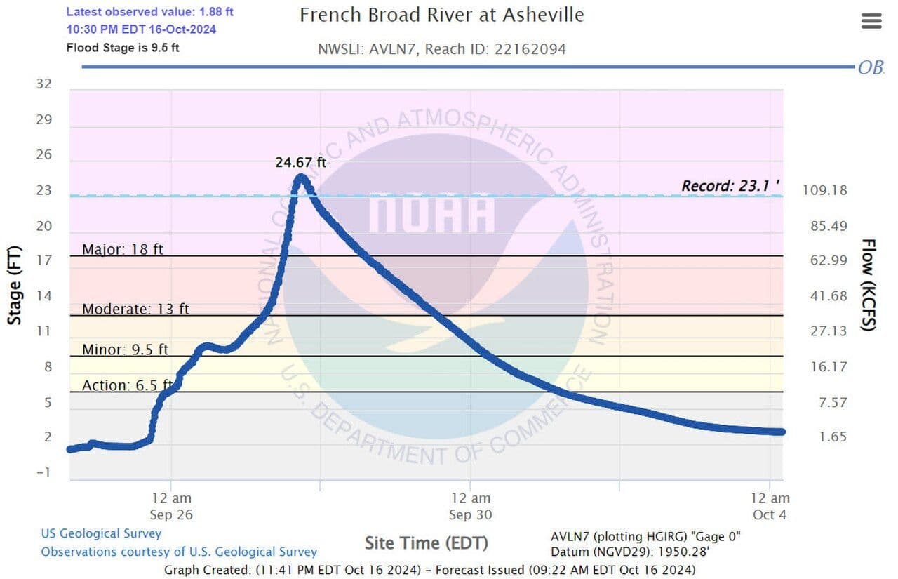
- The French Broad River at Asheville crested at 24.8 feet, beating the 1916 record of 23.1 feet. The Swannanoa at Biltmore peaked at 27.33 feet against a previous record of 20.7 feet (NHC report, updated February 17, 2026).
- Across a wide area, the rainfall had less than a 0.1% chance of happening in any given year (Climate.gov).
The human cost was heavy. North Carolina counted 108 storm-related deaths as of July 2025, and about 42 people died in Buncombe County, the most of any NC county (NCDHHS list as of June 17, 2025; BPR, July 9, 2025). NC damage was estimated at $59.6 billion, with about 73,700 homes damaged (NC Office of State Budget and Management, December 13, 2024). Asheville's boil-water notice was lifted on November 18, 2024 (EPA), after up to about seven or eight weeks without safe tap water, depending on the address.
Where the damage concentrated
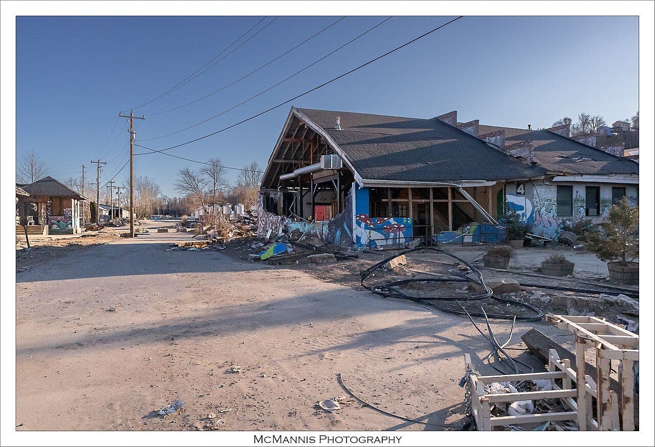
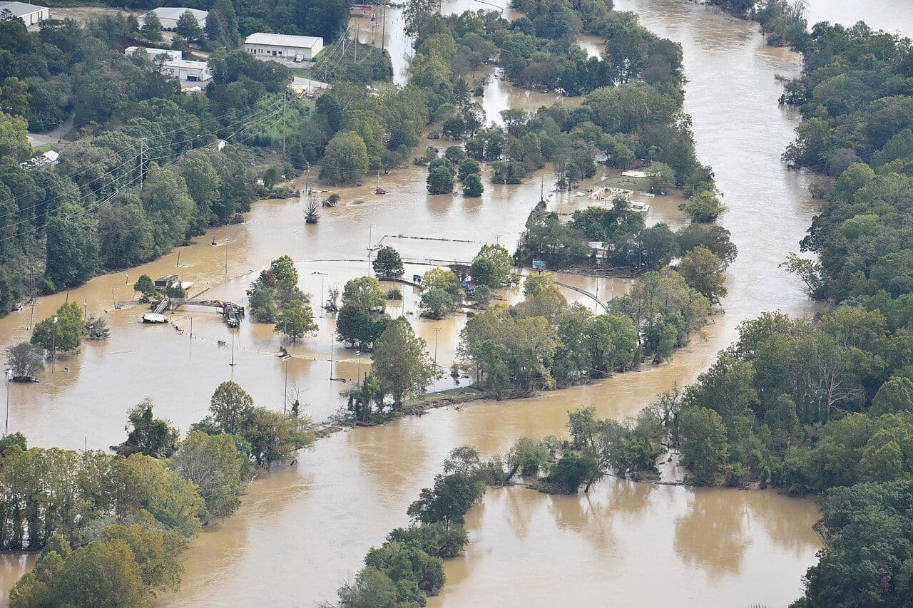
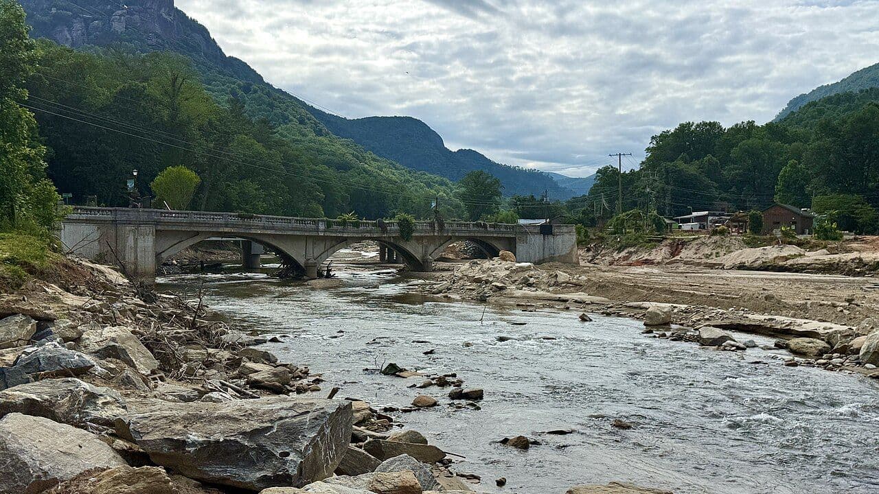
This pattern is the most useful thing for a buyer to understand. Damage clustered in river and creek bottoms (the French Broad, Swannanoa, Pigeon, Broad and Rocky Broad, and Mills rivers), on and below steep slopes, and along roads that follow creeks. Hard-hit places included the Swannanoa valley, Biltmore Village (35 of 40 potentially historic buildings substantially damaged, per BPR, January 29, 2025), the River Arts District, Chimney Rock and Lake Lure, and downtown Marshall.
Landslides were the other half of the story. The NC Geological Survey counts 496 landslides with impacts, more than all 358 it recorded from 1990 to 2023 (WUNC, January 9, 2026). The NHC and USGS, counting differently, put the total above 2,000 (NHC report, February 17, 2026).
Where recovery stands (September 2026)
- Water: 98% of damaged water systems in the region are restored, with about $750 million in repairs still ahead (NCLocal, September 24, 2026).
- Roads: more than 99% of damaged state roads have reopened (BPR, July 31, 2026). Private roads and bridges lag: 120 sites complete and 143 in progress out of about 3,000 approved (NCLocal).
- I-40 west toward Knoxville: one lane each way through the Pigeon River Gorge, with full completion estimated for late 2029 (BPR, September 3, 2026). That date has slipped before.
- Business districts: Biltmore Village is about 70% reoccupied, and the River Arts District is back to more than 600 artists working or showing there, against about 750 before the storm, and its artists' association has more members than before the flood (CoStar, September 23, 2026). Lake Lure refilled in May 2026 (NCLocal).
Buyouts. Under FEMA's Hazard Mitigation Grant Program, volunteering owners are paid the pre-disaster fair market value, the house is demolished, and the land becomes permanent open space. In Buncombe, FEMA had approved 251 of 278 submitted properties as of June 2026 (BPR, June 9, 2026). A lot next to a buyout parcel will stay undeveloped, and buyout lists show which streets were hit hardest.
New rebuilding rules. Asheville now requires non-exempt buildings in the floodplain to sit at least 2 feet above base flood elevation, and substantially damaged non-conforming buildings can no longer be grandfathered, apart from a historic-structure appeal (City Council, January 28, 2025). Buncombe's April 2026 amendments limit building in the "conveyance shadow" and ban RVs, sheds and stored materials in the floodway (Asheville.com, April 23, 2026). The "substantial improvement" rule, often called the 50% rule, can require a big renovation in a mapped floodplain to meet current elevation rules. Confirm the current threshold with the floodplain administrator before you plan a remodel.
Why the flood map is only a starting point
- The maps are old. Asheville's FEMA flood maps were last updated in 2010 (Washington Post via Stars and Stripes, October 13, 2024), and new federal floodplain boundaries "remain undrawn" as of September 2026 (CoStar).
- Few properties are in a mapped zone. Only about 2% of properties in the hardest-hit counties were inside a FEMA flood zone (NCLocal). In Buncombe, FEMA maps about 2,100 of roughly 125,000 properties in a flood zone, while First Street's model puts about 19,500 at substantial risk (Washington Post, October 2024).
- Floods miss maps in general. A UNC study found 43% of flooded NC buildings were outside FEMA's mapped floodplain across 78 events from 1996 to 2020, mostly in eastern NC, so it isn't a Helene figure (WRAL, July 21, 2025). I haven't found a verified figure for Helene itself.
A Zone X label tells you what the 2010 map shows. It can't guarantee water won't reach the house.
How to check a specific house
This is the checklist I work through with buyers.
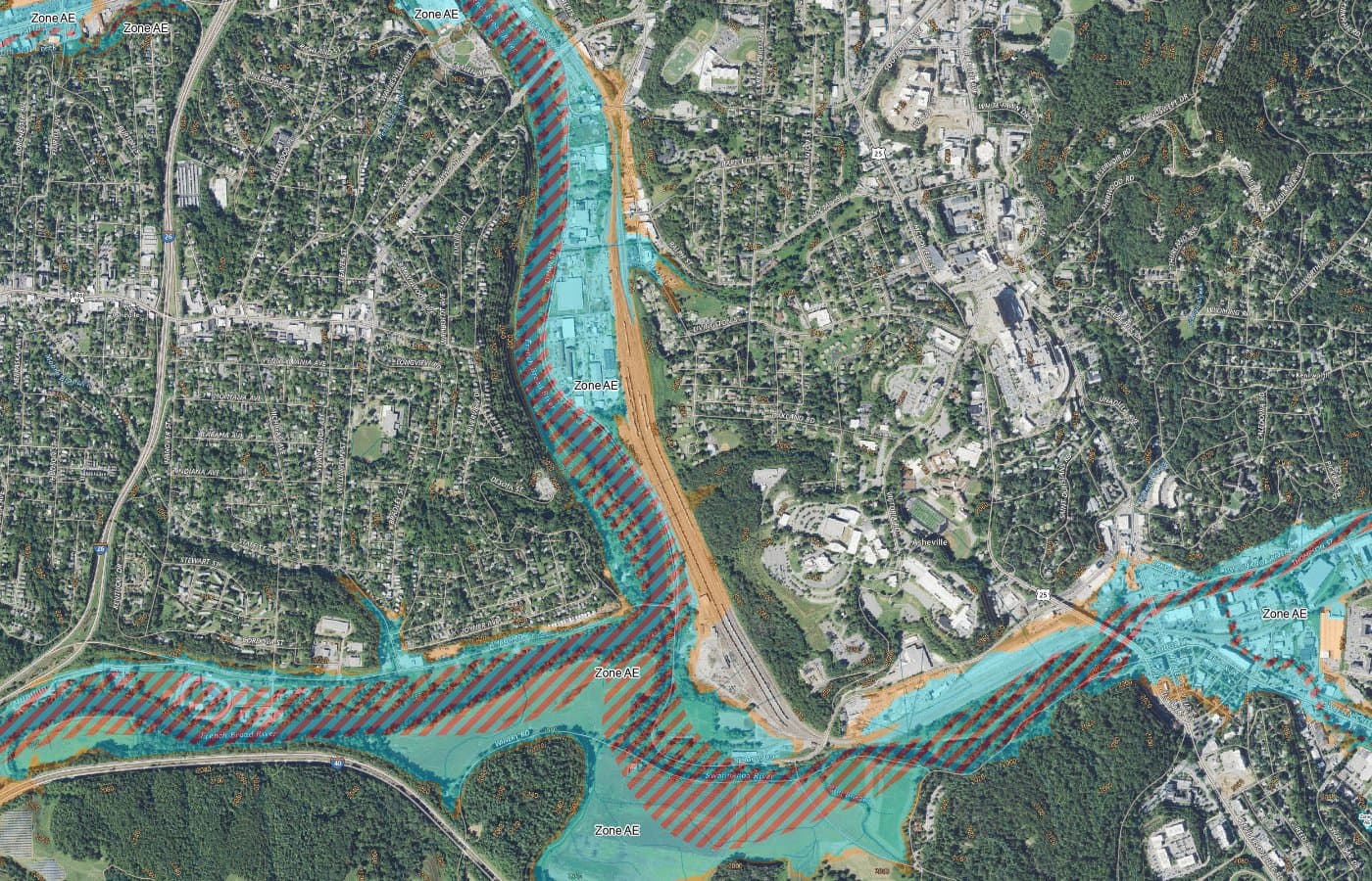
- Look up the maps. North Carolina's Flood Risk Information System (fris.nc.gov) shows effective and preliminary flood maps, property flood risk reports, and elevation certificates where one is on file.
- Check a modeled score. First Street publishes a free Flood Factor (1-10) at riskfactor.com. As of December 2025, Redfin showed it, Zillow linked to it, and Realtor.com was reviewing it (HousingWire, December 3, 2025). Critics say these models overstate risk in places, so use them to screen.
- Check the slope. The NC Geological Survey's Landslide Hazard Data Viewer shows mapped hazards, but only some counties have finished maps (WUNC, January 9, 2026). On a steep lot, or one on fill or below a slope, ask a geotechnical engineer.
- Find the elevation certificate. It compares the lowest floor to the base flood elevation and drives flood insurance pricing. Check FRIS, the seller, or the county floodplain office. A surveyor can prepare one.
- Read the seller's flood answers (next section).
- Check the access road. If a private road or bridge serves the house, ask whether Helene damaged it and who maintains it.
- Look next door. Is a neighboring parcel a buyout lot? Could a new map or ordinance change what can be rebuilt?
- Call the floodplain administrator. Buncombe's floodplain office is at 828-250-4830.
The flood questions on the NC disclosure form
Since July 1, 2024, North Carolina's Residential Property and Owners' Association Disclosure Statement has asked five flood questions (Coastal Review, July 19, 2024):
- Is the property in a federally designated or other flood hazard zone?
- Has it had flood, seepage or pooled-water damage from a natural event?
- Is there a current flood insurance policy?
- Is there an elevation certificate?
- Has the owner ever filed a flood insurance claim, including with the NFIP?
Sellers may answer "No Representation," even if they know. Treat an NR as a signal to ask more and check public records; by itself it proves nothing. A broker's duty to disclose known material facts applies regardless of the seller's answers (NC Real Estate Commission bulletin, April 2023). I also ask whether the house took on water or had a slide during Helene or in 2004, and whether the seller filed a FEMA or insurance claim.
Flood insurance: what to know before you call an agent
- Standard homeowners policies don't cover flood. Coverage comes from the National Flood Insurance Program (NFIP) or a private flood insurer.
- Very few people had it. Fewer than 1% of Buncombe structures carried NFIP coverage before Helene (Asheville Watchdog via Mountain Xpress, October 14, 2024), and only 5.2% of NC homes with FEMA-verified Helene flood damage had any flood insurance (NC OSBM, December 13, 2024).
- What it costs. Our own analysis of FEMA's OpenFEMA data found the median NFIP policy for a single-family home outside the high-risk zone ran about $650 to $900 a year across Buncombe, Henderson, Haywood, Madison and Transylvania (policies effective June 2025 through May 2026). Inside the high-risk zone, county medians ran about $1,100 to $1,370. Elevation, foundation and distance to water drive your quote.
- Timing. New NFIP policies generally have a 30-day waiting period, except when bought at a loan closing. Confirm on FloodSmart.gov.
Whether flood insurance makes sense for a particular house is a question for a licensed insurance agent. Ask for an NFIP quote and a private quote, even outside the mapped zone.
How this compares with what you know from Florida
I grew up in Gainesville, so I know the reflex: hurricane means wind and surge, and you watch the coast. Here there's no storm surge, and hurricane-force winds are rare this far inland. The mountains squeeze extra rain out of tropical air, so the risk shows up as flash flooding along rivers and creeks and landslides on steep, wet slopes (NC State Climate Office). It isn't new: in September 2004, Frances and Ivan hit two weeks apart, Biltmore Village flooded up to 5 feet, and about 400 landslides followed (NC State Climate Office, October 2019).
The straight talk
- Nobody can promise you a flood-free house. The maps are from 2010 and being redrawn, and heavy rain finds low spots the maps miss.
- Some of the prettiest settings carry the most risk. A creekside cottage or a house at the bottom of a steep hollow deserves the full checklist.
- Ridge lots trade one question for another. Higher ground lowers flood exposure but can add slope, driveway and winter-access questions.
- Sellers can decline to answer. An NR on the disclosure form is legal, so do your own checking.
Questions people ask
Can a hurricane still hurt the Asheville area? It can. The mountains don't get storm surge, and hurricane-force wind is rare this far inland. Tropical rain can still cause severe flooding and landslides, as Helene and the 2004 storms showed. The risk depends mostly on where a house sits relative to water and slopes.
If a house is outside the FEMA flood zone, is it low risk? Not necessarily. Asheville's FEMA maps date to 2010, and only about 2% of properties in the hardest-hit counties were in a mapped zone. Check FRIS, a First Street score, the landslide viewer and the flood history before you decide.
Do sellers have to tell me if the house flooded? Since July 1, 2024, the NC disclosure form asks five flood questions, but sellers may answer "No Representation." A broker must still disclose known material facts. Treat an NR answer as a reason to investigate.
Should I buy flood insurance outside a flood zone? That's a decision to make with a licensed insurance agent. Standard homeowners policies exclude flood, and NFIP policies outside the high-risk zone here had median costs of about $650 to $900 a year in 2025-26, per our analysis of FEMA data.
How do I know if a lot has landslide risk? Start with the NC Geological Survey's landslide hazard viewer, keeping in mind that not every county is mapped. For a steep lot, a lot on fill, or one below a slope, a geotechnical engineer can assess the site.
Next in this series
- A Second Home in the Mountains: the full picture if you're keeping Florida.
- Florida vs. North Carolina: The Real Costs: homeowners and flood insurance side by side.
- One-Level Homes: what to look for when terrain and stairs matter.
- Leaving Florida for Asheville: the front door to the whole series.
Get the Florida-to-Asheville Move Kit
The checklists, cost worksheet and flood questions I walk clients through, in one PDF.
Sources
- National Hurricane Center, Tropical Cyclone Report AL092024 (Helene), https://www.nhc.noaa.gov/data/tcr/AL092024_Helene.pdf (updated 2026-02-17)
- NOAA Climate.gov, Hurricane Helene's extreme rainfall and catastrophic inland flooding, https://www.climate.gov/news-features/event-tracker/hurricane-helenes-extreme-rainfall-and-catastrophic-inland-flooding (2024-11-07)
- BPR, NC list of Helene casualties updated, https://www.bpr.org/bpr-news/2025-07-09/nc-list-of-helene-casualties-updated-to-include-trucker-and-missing-man-from-tennessee (2025-07-09)
- NCDHHS, Hurricane Helene storm-related fatalities, https://www.ncdhhs.gov/assistance/hurricane-helene-recovery-resources/hurricane-helene-storm-related-fatalities (as of 2025-06-17)
- NC OSBM, Hurricane Helene Damage and Needs Assessment, https://www.osbm.nc.gov/hurricane-helene-dna/open (2024-12-13)
- EPA, City of Asheville lifts systemwide boil water notice, https://epa.gov/newsreleases/city-asheville-lifts-systemwide-boil-water-notice-issued-after-hurricane-helene (2024-11-19)
- BPR, Asheville adopts new floodplain construction rules, https://www.bpr.org/bpr-news/2025-01-29/last-night-at-council-asheville-adopts-new-floodplain-construction-rules (2025-01-29)
- City of Asheville, Council approves flood protection ordinance amendments, https://www.ashevillenc.gov/news/city-council-votes-to-approve-text-amendments-to-asheville-flood-protection-ordinance/ (Jan 2025)
- WUNC, Helene landslide hazard mapping program, https://www.wunc.org/term/news/2026-01-09/helene-landslide-hazard-mapping-program-emergencies (2026-01-09)
- NCLocal, Hurricane Helene two years later, https://nclocal.org/2026/09/24/hurricane-helene-two-years-later/ (2026-09-24)
- BPR, More than 99% of roads damaged by Helene have reopened, https://www.bpr.org/helene-recovery/2026-07-31/more-than-99-of-roads-damaged-by-helene-have-reopened-ncdot-says (2026-07-31)
- BPR, $2.8 billion Pigeon River Gorge I-40 repairs, https://www.bpr.org/helene-recovery/2026-09-03/2-8-billion-pigeon-river-gorge-i-40-repairs-nearly-triple-original-estimate (2026-09-03)
- CoStar, Asheville balances redevelopment and flood risk two years after Helene, https://www.costar.com/article/1672104780/asheville-north-carolina-balances-redevelopment-and-flood-risk-two-years-after-helene (2026-09-23)
- BPR, FEMA releases $172 million for Helene recovery, including buyouts, https://www.bpr.org/helene-recovery/2026-06-09/fema-releases-172-million-for-helene-recovery-including-29-million-for-buyouts-in-buncombe-county (2026-06-09)
- Asheville.com, Commissioners adopt changes to flood damage ordinance, https://www.asheville.com/news/2026/04/commissioners-hold-public-hearing-on-unified-fire-tax-district-adopt-changes-to-flood-damage-ordinance-and-more/ (2026-04-23)
- Buncombe County, Floodplain Development, https://www.buncombenc.gov/334/Floodplain-Development (accessed 2026-09-25)
- Stars and Stripes (Washington Post), FEMA flood maps underestimated risk, https://www.stripes.com/theaters/us/2024-10-13/fema-flood-maps-underestimated-risk-15495418.html (2024-10-13)
- WRAL, UNC study: flood-prone homes outside FEMA maps, https://www.wral.com/news/local/unc-study-flood-prone-homes-outside-fema-map-chapel-hill/ (2025-07-21)
- NC Flood Risk Information System, https://fris.nc.gov and help page https://fris.nc.gov/help (accessed Sept 2026)
- First Street, Buncombe County flood risk, https://firststreet.org/county/buncombe-county-nc/37021_fsid/flood (accessed Sept 2026)
- HousingWire, Redfin climate risk transparency, https://www.housingwire.com/articles/redfin-climate-risk-transparency/ (2025-12-03)
- NC DEQ, NC Geological Survey landslides, https://www.deq.nc.gov/about/divisions/energy-mineral-and-land-resources/nc-geological-survey/geologic-hazards-and-landslides (accessed Sept 2026)
- Coastal Review, Flood history questions added to real estate disclosure form, https://coastalreview.org/2024/07/flood-history-questions-added-to-real-estate-disclosure-form/ (2024-07-19)
- NCREC Bulletin, Questions and answers on the RPOADS form, https://bulletins.ncrec.gov/questions-and-answers-on-whats-happening-with-the-rpoads-form/ (Apr 2023)
- Mountain Xpress / Asheville Watchdog, Barely 1% of Buncombe structures carried flood insurance, https://mountainx.com/news/barely-1-of-buncombe-structures-carried-flood-insurance-data-show/ (2024-10-14)
- FEMA OpenFEMA NfipPolicies v3, https://www.fema.gov/api/open/v3/NfipPolicies (queried 2026-09-25; our analysis)
- NC State Climate Office, Hurricane hazards, https://products.climate.ncsu.edu/weather/hurricanes/hazards/ (accessed Sept 2026)
- NC State Climate Office, A tropical trio in September 2004, https://climate.ncsu.edu/blog/2019/10/a-tropical-trio-in-september-2004-tested-the-mountain-terrain/ (Oct 2019)